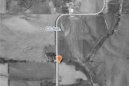
Longstreth Cemetery aerial view (Image from the U.S. Geological Survey)
Longstreth Cemetery
This burial index is complete to 1975 (see Pauline Lillie's history), although it is thought other burials were made. Longstreth is designated as a Pioneer Cemetery.
History: Pauline Lillie's 1976 History
Gravestone Photos: Iowa Gravestone Photo Project
Plot Map: none
Condition: See Pauline Lillie's 1976 history (need update).
Directions and Location Maps:
Interactive Location Map w/GPS
Directions Map
From Victor
- Head east on 3rd St toward Williams St (0.6 mi)
- Turn right at V38 (7.8 mi)
- Turn left at 265th St (1.3 mi)
- Turn left at CC Ave (0.3 mi)
Coordinates: (DEC) Latitude 41.6266708 Longitude -92.2546271
Credits:
Transcribed by: Fran Eichler from Pauline Lillie's Cemetery History
Cemetery Photos by: Virginia Threlkeld-Larson (with transcription notes)
Web page by: Stephen Williams
Published: Iowa County IAGenWeb Website, 30 Nov 2008. Permission given by Lou Eichler (Fran's husband).
Media Source: Iowa County Cemetery Stones & History 1844-1975 via gravestone inscriptions
Cemetery Photos by: Virginia Threlkeld-Larson (with transcription notes)
Web page by: Stephen Williams
Published: Iowa County IAGenWeb Website, 30 Nov 2008. Permission given by Lou Eichler (Fran's husband).
Media Source: Iowa County Cemetery Stones & History 1844-1975 via gravestone inscriptions
Cemetery Listing:
![up/down arrows [sort arrows]](../../js/images/arrow-up-down.png) or
or ![sort direction [up arrow]](../../js/images/arrow-up.png) to sort.
to sort.